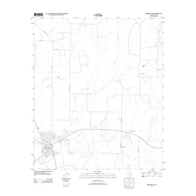
2012 Map of Robert Lee
USGS Topo · Published 2012About this map
Robert Lee serves as the focal point of this Coke County landscape, situated along the north bank of the Colorado River. The town's grid is clearly defined, with streets like Austin St and Colorado St leading toward the river and nearby water features such as Old City Lake. The surrounding area reflects a mix of petroleum extraction and rural heritage, evidenced by the Munn Oil Field and McCuthen Oil Field interspersed with historic burial grounds. To the east, the prominent elevation of Hayrick Mtn rises above the drainage of Indian Cr and Cow Cr. This survey illustrates a complex network of local routes, including the Sanco Loop and Graham Valley Rd, which connect the scattered agricultural and industrial operations throughout the valley.
Find a feature on this map
41 named features on this map. Tap any name to fly to it.
Don’t see what you’re looking for? This feature index may not catch every label — zoom into the map to look around manually.
Map Details
Editions of this 2012 Robert Lee Map
This is the sole edition of this map. No revisions or reprints were ever made.
Other maps of this area

1891 · Hayrick
USGS Topo · 1:125,000

1893 · Sweetwater
USGS Topo · 1:125,000

1894 · Hayrick
USGS Topo · 1:125,000

1921 · Bronte
USGS Topo · 1:31,680

1921 · Mays School
USGS Topo · 1:31,680

1954 · Big Spring
USGS Topo · 1:250,000

1954 · San Angelo
USGS Topo · 1:250,000

1958 · San Angelo
USGS Topo · 1:250,000

1958 · Big Spring
USGS Topo · 1:250,000
1961 · Shawville
USGS Topo · 1:24,000