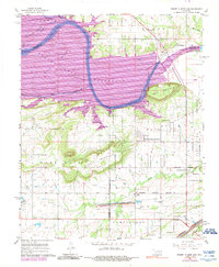
1967 Map of Robert S Kerr Dam
USGS Topo · Published 1989About this map
The Robert S. Kerr Reservoir dominates the landscape of eastern Oklahoma as it appeared in the late 1960s, inundating the vast floodplains of the Arkansas River. The transition from river to reservoir is captured here, showing the submerged contours of Mulehead Bottom and Blaine Bottom. Elevated terrain like Short Mountain and McCann Mountain rise sharply above the water, while the peaks of Sans Bois Gingle Mountain and Brushy Knob define the southern horizon.
Find a feature on this map
32 named features on this map. Tap any name to fly to it.
Don’t see what you’re looking for? This feature index may not catch every label — zoom into the map to look around manually.
Map Details
Editions of this 1967 Robert S Kerr Dam Map
3 editions found
Other maps of this area

1900 · Sallisaw
USGS Topo · 1:125,000

1911 · Sallisaw
USGS Topo · 1:125,000

1946 · Fort Smith
USGS Topo · 1:250,000

1965 · Fort Smith
USGS Topo · 1:250,000

1966 · Gans
USGS Topo · 1:24,000

1966 · Muldrow SW
USGS Topo · 1:24,000

1967 · Fort Smith
USGS Topo · 1:250,000
1967 · Keota
USGS Topo · 1:24,000
1967 · Sallisaw
USGS Topo · 1:24,000

1967 · Robert S Kerr Dam
USGS Topo · 1:24,000