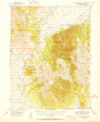
1951 Map of Roberts Creek Mtn
USGS Topo · Published 1951About this map
Indian Ranch and several other cattle-and-horse operations like Three Bar Ranch anchor this landscape in the mid-20th century. Situated at the intersection of the Roberts Mountains and the expansive Denay Valley, the map reveals a high-desert ranching economy dependent on a network of springs and seasonal watercourses. The presence of the Jackass Creek Prospect points to the area's legacy of mineral exploration, while high-altitude points like Roberts Creek Mtn and Western Pk dominate the eastern topography. A Summer Camp located near the headwaters of Roberts Creek suggests the seasonal movement of people or livestock through these canyons. From the remote crossing at McClusky Pass to the descent into Meadow Canyon, the map documents a transition from rugged peaks to the irrigated flats where Willow Creek Ranch sits at the valley's edge.
Find a feature on this map
43 named features on this map. Tap any name to fly to it.
Don’t see what you’re looking for? This feature index may not catch every label — zoom into the map to look around manually.
Map Details
Editions of this 1951 Roberts Creek Mtn Map
2 editions found
Other maps of this area

1926 · Roberts Mountains
USGS Topo · 1:250,000

1929 · Roberts Mountains
USGS Topo · 1:250,000

1937 · Mineral Hill
USGS Topo · 1:48,000

1938 · Cortez
USGS Topo · 1:48,000

1943 · Mineral Hill
USGS Topo · 1:62,500

1944 · Cortez
USGS Topo · 1:62,500

1949 · Garden Valley
USGS Topo · 1:62,500

1949 · Roberts Creek Mtn
USGS Topo · 1:62,500

1951 · Roberts Creek Mtn
USGS Topo · 1:62,500

1951 · Garden Valley
USGS Topo · 1:62,500