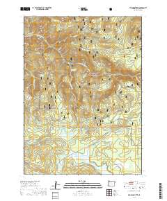
2020 Map of Robinson Butte
USGS Topo · Published 2020About this map
Rogue River National Forest lands dominate this high-elevation terrain, where complex water systems like the S Fork Little Butte Cr and Dead Indian Cr define the drainage patterns. The northern shore of Howard Prairie Lake provides a significant focal point in the south, while the landscape is punctuated by prominent volcanic and topographic features including Robinson Butte, Shell Rock Butte, and Dead Indian Mtn. Historically significant corridors such as the Dead Indian Memorial Rd traverse the area, connecting various high-mountain clearings.
Find a feature on this map
40 named features on this map. Tap any name to fly to it.
Don’t see what you’re looking for? This feature index may not catch every label — zoom into the map to look around manually.
Map Details
Editions of this 2020 Robinson Butte Map
This is the sole edition of this map. No revisions or reprints were ever made.
Other maps of this area

1891 · Ashland
USGS Topo · 1:250,000

1893 · Ashland
USGS Topo · 1:250,000

1897 · Ashland
USGS Topo · 1:250,000

1938 · Medford
USGS Topo · 1:125,000

1954 · Lakecreek
USGS Topo · 1:62,500

1954 · Ashland
USGS Topo · 1:62,500

1955 · Hyatt Reservoir
USGS Topo · 1:62,500

1955 · Mt. Mc Loughlin
USGS Topo · 1:62,500

1955 · Medford
USGS Topo · 1:250,000

1957 · Medford
USGS Topo · 1:250,000