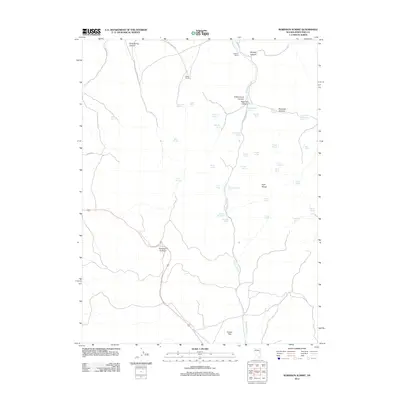
2012 Map of Robinson Summit
USGS Topo · Published 2012About this map
The Egan Range dominates this portion of White Pine County, where high-altitude geography dictates the location of early ranching outposts and a network of named water sources. Significant landmarks such as Robinson Summit and Piscevich Summit provide natural passage through the high country, while Copper Flat in the south points to the area's geological and mining interests. Isolated ranching operations, including Robison Ranch and Miller Ranch, appear as critical nodes along the primitive road network defined by Gleason Creek Rd and White Pine Co Rd.
Find a feature on this map
46 named features on this map. Tap any name to fly to it.
Don’t see what you’re looking for? This feature index may not catch every label — zoom into the map to look around manually.
Map Details
Editions of this 2012 Robinson Summit Map
This is the sole edition of this map. No revisions or reprints were ever made.
Other maps of this area

1952 · Ely
USGS Topo · 1:125,000

1956 · Ely
USGS Topo · 1:250,000

1958 · Ruth
USGS Topo · 1:24,000

1958 · McGill
USGS Topo · 1:62,500

1958 · Reipetown
USGS Topo · 1:24,000

1959 · Ely
USGS Topo · 1:250,000

1959 · Reipetown
USGS Topo · 1:62,500

1963 · Ely
USGS Topo · 1:250,000

1979 · Mt. Hamilton
USGS Topo · 1:100,000
1982 · Steptoe Ranch
USGS Topo · 1:24,000