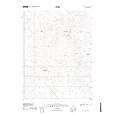
2018 Map of Robinson Summit
USGS Topo · Published 2018About this map
Robinson Summit serves as the namesake for this high-elevation landscape in White Pine County, where the topography of the Egan Range is defined by a dense network of seasonal water sources. The importance of groundwater in this arid region is evident by the dozens of named springs, including Schoolhouse Spring, Jamestown Spring, and Summit Springs, which likely supported early ranching or travel through the mountain passes. The terrain is deeply incised by numerous drainages such as Bradley Canyon and Sage Hen Canyon, while Piscevich Summit marks a significant high point on the eastern side of the sheet. Modern infrastructure is represented by the Gleason Creek Rd and various county roads, though the underlying settlement pattern remains tied to the historical reliance on isolated water points like Buffalo Spring and Grassy Spring.
Find a feature on this map
50 named features on this map. Tap any name to fly to it.
Don’t see what you’re looking for? This feature index may not catch every label — zoom into the map to look around manually.
Map Details
Editions of this 2018 Robinson Summit Map
This is the sole edition of this map. No revisions or reprints were ever made.
Other maps of this area

1952 · Ely
USGS Topo · 1:125,000

1956 · Ely
USGS Topo · 1:250,000

1958 · Ruth
USGS Topo · 1:24,000

1958 · McGill
USGS Topo · 1:62,500

1958 · Reipetown
USGS Topo · 1:24,000

1959 · Ely
USGS Topo · 1:250,000

1959 · Reipetown
USGS Topo · 1:62,500

1963 · Ely
USGS Topo · 1:250,000

1979 · Mt. Hamilton
USGS Topo · 1:100,000
1982 · Steptoe Ranch
USGS Topo · 1:24,000