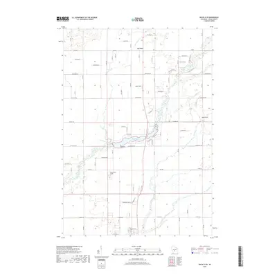
2018 Map of Roche A Cri
USGS Topo · Published 2018About this map
Big Roche a Cri Lake and its surrounding wetlands form the central focal point of this Adams County landscape, where the waters of Big Roche a Cri Creek are impounded before continuing their westward course. The terrain is defined by striking geological formations that rise abruptly from the sandy plains, including Rabbit Rock, Minnie Rock, and the jagged Cottonville Rocks. These sandstone outcrops serve as ancient landmarks in a region largely dominated by a grid of agricultural and residential roads. The small settlement of Big Flats sits in the northern section, while Roche a Cri occupies the southern reaches near the creek's path. Local history is anchored by the Cottonville Cem, situated near the lake's western edge. A complex drainage network including Dead Horse Cr, Dry Cr, and Carter Cr illustrates the hydrology of the Central Sand Plains during the early 21st century.
Find a feature on this map
39 named features on this map. Tap any name to fly to it.
Don’t see what you’re looking for? This feature index may not catch every label — zoom into the map to look around manually.
Map Details
Editions of this 2018 Roche A Cri Map
This is the sole edition of this map. No revisions or reprints were ever made.
Other maps of this area

1955 · Green Bay
USGS Topo · 1:250,000

1957 · Madison
USGS Topo · 1:250,000

1958 · Arkdale
USGS Topo · 1:48,000

1958 · Coloma
USGS Topo · 1:48,000

1960 · Madison
USGS Topo · 1:250,000

1961 · Oxford
USGS Topo · 1:62,500

1961 · Adams
USGS Topo · 1:62,500

1967 · Roche A Cri
USGS Topo · 1:24,000

1967 · Arkdale NE
USGS Topo · 1:24,000
1967 · Arkdale
USGS Topo · 1:24,000