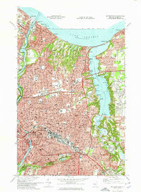
1971 Map of Rochester East
USGS Topo · Published 1974About this map
The eastern expanse of Rochester meets the shoreline of Lake Ontario in this 1971 survey, showing a landscape defined by industrial rail corridors and suburban growth. The Penn Central and Erie Lackawanna Ry networks slice through the city, connecting the busy port area at Charlotte to the residential developments of Brighton and Twelve Corners. To the east, Irondequoit Bay remains a prominent natural feature, dotted with legacy settlements like Sea Breeze and Glen Haven, which were historically reached by recreation-seekers from the city center.
Find a feature on this map
80 named features on this map. Tap any name to fly to it.
Don’t see what you’re looking for? This feature index may not catch every label — zoom into the map to look around manually.
Map Details
Editions of this 1971 Rochester East Map
3 editions found
Other maps of this area

1895 · Rochester
USGS Topo · 1:62,500

1895 · Ontario Beach
USGS Topo · 1:62,500

1898 · Rochester
USGS Topo · 1:62,500

1899 · Ontario Beach
USGS Topo · 1:62,500

1900 · Macedon
USGS Topo · 1:62,500

1912 · Rochester
USGS Topo · 1:62,500

1912 · Ontario Beach
USGS Topo · 1:62,500

1920 · Rochester
USGS Topo · 1:62,500

1931 · Mendon Ponds
USGS Topo · 1:24,000

1931 · Rochester West
USGS Topo · 1:24,000