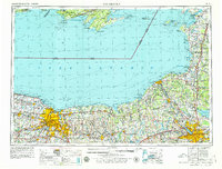
1961 Map of Rochester
USGS Topo · Published 1979About this map
Lake Ontario dominates the northern half of this landscape, its southern shoreline defined by the strategic waterways of the Erie Canal and the Genesee River. The region centers on the burgeoning urban corridors of Rochester and Syracuse, connected by the New York State Thruway and the heavy industrial rail lines of the Penn Central. This 1960s-era geography reflects a post-war period of suburban expansion into towns like Irondequoit, Brighton, and Liverpool.
Find a feature on this map
148 named features on this map. Tap any name to fly to it.
Don’t see what you’re looking for? This feature index may not catch every label — zoom into the map to look around manually.
Map Details
Editions of this 1961 Rochester Map
3 editions found

Other maps of this area

1893 · Sackets Harbor
USGS Topo · 1:62,500

1895 · Chittenango
USGS Topo · 1:62,500

1895 · Sacketts Harbor
USGS Topo · 1:62,500

1895 · Rochester
USGS Topo · 1:62,500

1895 · Stony Island
USGS Topo · 1:62,500

1895 · Ontario Beach
USGS Topo · 1:62,500

1895 · Pulaski
USGS Topo · 1:62,500

1895 · Watertown
USGS Topo · 1:62,500

1895 · Cape Vincent
USGS Topo · 1:62,500

1895 · Syracuse
USGS Topo · 1:62,500