
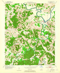
1953 Map of Rochester
USGS Topo · Published 1954About this map
The Green River meanders sharply along the border of Ohio, Muhlenberg, and Butler Counties, anchoring a landscape defined by river commerce and rural agriculture in the early 1950s. At the confluence of the Green and Mud River, the town of Rochester serves as a focal point, situated near Lock No 3 and Town Lake. This era shows a distributed network of small communities and social centers, including Knightsburg, Skilesville, and Ennis, each supported by local institutions like Union Chapel and Forest Grove Ch.
Find a feature on this map
47 named features on this map. Tap any name to fly to it.
Don’t see what you’re looking for? This feature index may not catch every label — zoom into the map to look around manually.
Map Details
Editions of this 1953 Rochester Map
2 editions found
Other maps of this area

1909 · Hartford
USGS Topo · 1:62,500

1909 · Central City
USGS Topo · 1:62,500

1911 · Drakesboro
USGS Topo · 1:48,000

1911 · Dunmor
USGS Topo · 1:48,000

1913 · Drakesboro
USGS Topo · 1:62,500

1914 · Dunmor
USGS Topo · 1:62,500

1953 · Drakesboro
USGS Topo · 1:24,000

1953 · Rosewood
USGS Topo · 1:24,000

1953 · Central City East
USGS Topo · 1:24,000

1953 · Dunmor
USGS Topo · 1:24,000