
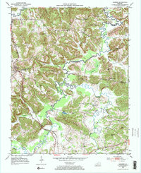
1953 Map of Dunmor
USGS Topo · Published 1954About this map
Mud River meanders through the central lowlands of this 1950s landscape, serving as a natural boundary between Muhlenberg, Butler, and Logan Counties. The terrain is defined by a series of prominent ridges, including Chestnut Oak Ridge and Welburn Ridge, which overlook the dispersed settlements of Penrod and Dunmor. This era shows a community rooted in small-scale industry and rural institutions, evidenced by the presence of numerous oil wells and schools like North Logan Sch. The Louisville and Nashville railroad runs along the western edge, connecting the coal and timber resources of the ridges to the wider region. In the south, the winding course of Wolf Lick Creek passes by Diamond Springs, while Coon Range Lake sits tucked against the slopes of Iron Mountain, illustrating how the local geography dictated both the transit corridors and the pockets of agricultural life.
Find a feature on this map
45 named features on this map. Tap any name to fly to it.
Don’t see what you’re looking for? This feature index may not catch every label — zoom into the map to look around manually.
Map Details
Editions of this 1953 Dunmor Map
2 editions found
Other maps of this area

1911 · Drakesboro
USGS Topo · 1:48,000

1911 · Dunmor
USGS Topo · 1:48,000

1913 · Drakesboro
USGS Topo · 1:62,500

1914 · Dunmor
USGS Topo · 1:62,500

1951 · Lewisburg
USGS Topo · 1:24,000

1951 · Homer
USGS Topo · 1:24,000

1952 · Sharon Grove
USGS Topo · 1:24,000

1953 · Drakesboro
USGS Topo · 1:24,000

1953 · Rosewood
USGS Topo · 1:24,000

1953 · South Hill
USGS Topo · 1:24,000