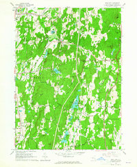
1963 Map of Rock City
USGS Topo · Published 1965About this map
The town of Red Hook and the surrounding Hudson Valley hamlets are defined by a mix of historic institutional land use and rural crossroads in this early 1960s survey. Significant landmarks include the Old Rhinebeck Aerodrome and several recreational camps such as Camp Kanawha Minawha and Camp Boiberik, reflecting the area's mid-century role as a retreat destination. The landscape is carved by the Saw Kill and Landsman Kill, feeding into numerous water bodies like Silver Lake and Sepasco Lake.
Find a feature on this map
95 named features on this map. Tap any name to fly to it.
Don’t see what you’re looking for? This feature index may not catch every label — zoom into the map to look around manually.
Map Details
Editions of this 1963 Rock City Map
3 editions found
Other maps of this area

1895 · Catskill
USGS Topo · 1:62,500

1898 · Rhinebeck
USGS Topo · 1:62,500

1899 · Millbrook
USGS Topo · 1:62,500

1902 · Millbrook
USGS Topo · 1:62,500

1902 · Copake
USGS Topo · 1:62,500

1904 · Copake
USGS Topo · 1:62,500

1934 · Rhinebeck
USGS Topo · 1:48,000

1934 · Catskill
USGS Topo · 1:62,500

1938 · Catskill
USGS Topo · 1:62,500

1939 · Rhinebeck
USGS Topo · 1:62,500