
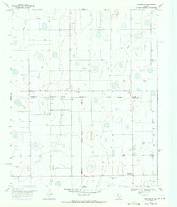
1965 Map of Rock Creek
USGS Topo · Published 1967About this map
The High Plains of the Texas Panhandle are defined here by the Swisher Co Briscoe Co line, which divides this landscape of playa lakes and intermittent drainages. The topography is largely characterized by a series of depressions subject to controlled inundation, punctuating a vast agricultural and ranching expanse. A significant northern drainage feature, Rock Creek, cuts through the terrain, fed by a localized Spring and carving out the most varied elevation on the sheet. Human presence is sparse, centered around the settlement of Rock Creek and the small locality of Mercer. The infrastructure of the mid-1960s is represented by a small Landing Field and a power Substa, reflecting the era's reliance on localized aviation and the expanding rural electrical grid.
Find a feature on this map
8 named features on this map. Tap any name to fly to it.
Don’t see what you’re looking for? This feature index may not catch every label — zoom into the map to look around manually.
Map Details
Editions of this 1965 Rock Creek Map
This is the sole edition of this map. No revisions or reprints were ever made.
Other maps of this area

1954 · Plainview
USGS Topo · 1:250,000

1958 · Plainview
USGS Topo · 1:250,000

1965 · Ross Canyon
USGS Topo · 1:24,000

1965 · Whiteley
USGS Topo · 1:24,000

1965 · Silverton
USGS Topo · 1:24,000

1965 · Silverton SW
USGS Topo · 1:24,000

1965 · Cope Creek
USGS Topo · 1:24,000

1969 · Love
USGS Topo · 1:24,000

1969 · Claytonville
USGS Topo · 1:24,000
1969 · Providence
USGS Topo · 1:24,000