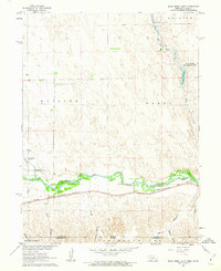
1961 Map of Rock Creek Lake
USGS Topo · Published 1963About this map
Republican River valley life and water management define this early 1960s study of the Nebraska-Kansas border. The landscape is dominated by the sprawling braided channel of the river, paralleled closely by the Chicago Burlington and Quincy railroad, a vital transit corridor through Dundy and Cheyenne counties. Further north, the State Fish Hatchery and Rock Creek Recreation Area represent mid-century conservation efforts centered around Rock Creek Lake. This area, encompassing parts of Allston and Haigler, showcases a rugged terrain of deeply incised drainages like Colter Canyon and Jackson Canyon that feed toward the river. The presence of a Gaging Station and various wells reflects the critical importance of water monitoring in this agricultural borderland.
Find a feature on this map
22 named features on this map. Tap any name to fly to it.
Don’t see what you’re looking for? This feature index may not catch every label — zoom into the map to look around manually.
Map Details
Editions of this 1961 Rock Creek Lake Map
This is the sole edition of this map. No revisions or reprints were ever made.
Other maps of this area

1942 · St. Francis
USGS Topo · 1:62,500

1943 · St. Francis
USGS Topo · 1:62,500

1951 · St Francis
USGS Topo · 1:62,500

1951 · Bird City North
USGS Topo · 1:62,500

1954 · McCook
USGS Topo · 1:250,000

1954 · Goodland
USGS Topo · 1:250,000

1956 · Goodland
USGS Topo · 1:250,000

1957 · McCook
USGS Topo · 1:250,000

1957 · Goodland
USGS Topo · 1:250,000

1958 · McCook
USGS Topo · 1:250,000