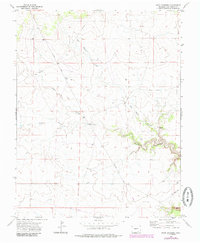
1972 Map of Rock Crossing
USGS Topo · Published 1985About this map
Rock Crossing serves as the focal point for this Las Animas County survey, where the arid landscape is defined by a network of drainage channels. The prominent Big Water Arroyo and Taylor Arroyo converge in the eastern section of the quadrangle, with the latter showing distinctive meandering patterns through the canyon floor. These watercourses, along with Burke Arroyo, represent the primary topographic features in an otherwise sparse high-plains environment. Human activity is evidenced by infrastructure such as a long Pipeline stretching across the northwest and a small Landing Strip located in the southeast corner. Sparse water sources like the Spring near the eastern boundary and scattered Well sites suggest the vital importance of water management for ranching or local industry during the early 1970s and subsequent 1980s updates.
Find a feature on this map
8 named features on this map. Tap any name to fly to it.
Don’t see what you’re looking for? This feature index may not catch every label — zoom into the map to look around manually.
Map Details
Editions of this 1972 Rock Crossing Map
4 editions found
Other maps of this area

1891 · Timpas
USGS Topo · 1:125,000

1891 · Apishapa
USGS Topo · 1:125,000

1891 · Mesa De Maya
USGS Topo · 1:125,000

1892 · Elmoro
USGS Topo · 1:125,000

1893 · Apishapa
USGS Topo · 1:125,000

1893 · Elmoro
USGS Topo · 1:125,000

1893 · Mesa de Maya
USGS Topo · 1:125,000

1894 · Timpas
USGS Topo · 1:125,000

1897 · Elmoro
USGS Topo · 1:125,000

1897 · Apishapa
USGS Topo · 1:125,000