
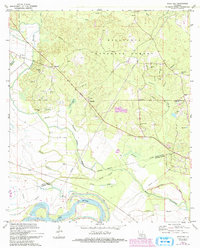
1972 Map of Rock Hill
USGS Topo · Published 1974About this map
Kisatchie National Forest covers much of this landscape north of the Red River, where a complex network of waterways including Bayou Rigolette and Hudson Creek bisect the terrain. The map captures a transition from the wooded uplands near Rock Hill and Bagdad down to the alluvial bottomlands, where a significant Levee system protects the banks of the main river channel. Transport and industry are marked by the presence of the Kansas City Southern railroad line and several active Gravel Pits concentrated in the eastern portion of the survey. For local historians, the sheet is dense with family and community landmarks, documenting several rural congregations and burial grounds such as Bethlehem Ch, Cruikshank Cem, and Anthony Cem that served the area's dispersed residents during the early 1970s.
Find a feature on this map
42 named features on this map. Tap any name to fly to it.
Don’t see what you’re looking for? This feature index may not catch every label — zoom into the map to look around manually.
Map Details
Editions of this 1972 Rock Hill Map
2 editions found
Other maps of this area

1932 · Boyce NE
USGS Topo · 1:31,680

1932 · Boyce SW
USGS Topo · 1:31,680

1932 · Colfax SW
USGS Topo · 1:31,680

1932 · Colfax SE
USGS Topo · 1:31,680

1936 · Colfax
USGS Topo · 1:62,500

1936 · Pollock
USGS Topo · 1:62,500

1941 · Alexandria
USGS Topo · 1:62,500

1941 · Pollock
USGS Topo · 1:62,500

1941 · Boyce
USGS Topo · 1:62,500

1945 · Boyce SE
USGS Topo · 1:31,680