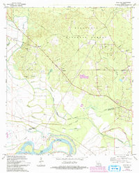
1972 Map of Rock Hill
USGS Topo · Published 1993About this map
Red River currents define the southern boundary of this central Louisiana landscape, where the meandering waterway carves through the transition from Grant Parish to Rapides Parish. The northern reaches are dominated by the wooded expanse of the Kisatchie National Forest, a terrain marked by an intricate network of drainage branches including Moccasin Branch and Hudson Branch. Settlement patterns in the early 1970s reveal a cluster of rural activity centered around the small community of Rock Hill, with numerous country churches and family burial grounds scattered throughout the timberland.
Find a feature on this map
33 named features on this map. Tap any name to fly to it.
Don’t see what you’re looking for? This feature index may not catch every label — zoom into the map to look around manually.
Map Details
Editions of this 1972 Rock Hill Map
2 editions found

Other maps of this area

1932 · Boyce NE
USGS Topo · 1:31,680

1932 · Boyce SW
USGS Topo · 1:31,680

1932 · Colfax SW
USGS Topo · 1:31,680

1932 · Colfax SE
USGS Topo · 1:31,680

1936 · Colfax
USGS Topo · 1:62,500

1936 · Pollock
USGS Topo · 1:62,500

1941 · Alexandria
USGS Topo · 1:62,500

1941 · Pollock
USGS Topo · 1:62,500

1941 · Boyce
USGS Topo · 1:62,500

1945 · Boyce SE
USGS Topo · 1:31,680