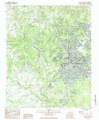
1984 Map of Rock Hill West
USGS Topo · Published 1985About this map
Rock Hill serves as the focal point of this mid-1980s survey, illustrating a period of significant educational and institutional density in York County. The landscape is defined by its prominent academic centers, including Winthrop College, Friendship College, and Clinton Jr College Park, which anchor the urban fabric alongside numerous neighborhood schools like Ebinport Sch and Ebenezer Ave Sch. The transition from the developed core of Boyd Hill to the rural outskirts is marked by a network of local churches such as Mount Olive Ch and Tirzah Ch, many of which sit near established family landmarks and cemeteries like Forest Hills Cem.
Find a feature on this map
63 named features on this map. Tap any name to fly to it.
Don’t see what you’re looking for? This feature index may not catch every label — zoom into the map to look around manually.
Map Details
Editions of this 1984 Rock Hill West Map
2 editions found
Other maps of this area

1905 · Charlotte
USGS Topo · 1:48,000

1907 · Charlotte
USGS Topo · 1:62,500

1941 · Charlotte
USGS Topo · 1:125,000

1941 · Spartanburg
USGS Topo · 1:250,000

1942 · Charlotte
USGS Topo · 1:125,000

1947 · Clover
USGS Topo · 1:62,500

1949 · Clover
USGS Topo · 1:62,500

1949 · Rock Hill
USGS Topo · 1:62,500

1953 · Spartanburg
USGS Topo · 1:250,000

1953 · Charlotte
USGS Topo · 1:250,000