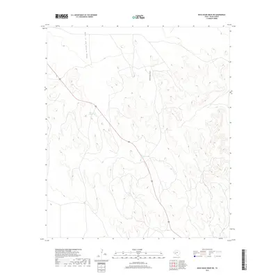
2019 Map of Rock House Draw NW
USGS Topo · Published 2019About this map
Hole in the Ground Draw dominates the northwest corner of this West Texas landscape, leading into a complex network of arid drainage patterns within Pecos County. The terrain is defined by dry watercourses such as South Linger Draw, which illustrate the natural watershed of this high desert region. Water management is a central theme of the local geography, evidenced by strategically placed features like Stockton Tank and Hole-in-the-Ground Tank situated along the topography's natural contours. These tanks are vital markers of ranching or land use in a territory where permanent surface water is scarce. Route 285 cuts a sharp diagonal across the center of the sheet, providing the primary corridor through this otherwise unpopulated expanse of Texas hinterland.
Find a feature on this map
5 named features on this map. Tap any name to fly to it.
Don’t see what you’re looking for? This feature index may not catch every label — zoom into the map to look around manually.
Map Details
Editions of this 2019 Rock House Draw NW Map
This is the sole edition of this map. No revisions or reprints were ever made.
Other maps of this area

1921 · Fort Stockton
USGS Topo · 1:62,500

1923 · Fort Stockton
USGS Topo · 1:62,500

1923 · Sierra Madera
USGS Topo · 1:62,500

1928 · Comanche Spring
USGS Topo · 1:125,000

1954 · Fort Stockton
USGS Topo · 1:250,000

1958 · Fort Stockton
USGS Topo · 1:250,000
1970 · Panther Bluff
USGS Topo · 1:24,000
1970 · East Mesa SW
USGS Topo · 1:24,000
1970 · Fivemile Mesa
USGS Topo · 1:24,000

1973 · Fort Stockton
USGS Topo · 1:250,000