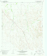
1980 Map of Rock House Draw NW
USGS Topo · Published 1980About this map
South Linger Draw and the complex topography of Pecos County define this arid landscape during the mid-1970s. The map illustrates a region where water management was critical for ranching or industry, marked by man-made catchments like Hole-in-the-Ground Tank and Stockton Tank. The presence of several Gravel Pits, a Well, and a Drill Hole suggests active resource extraction and exploration in the vicinity of Kincaid. Transportation through this territory relied on a mix of primary roads and a more rudimentary Jeep Trail network, while a remote Landing Strip in the southern portion provided aerial access to this expansive terrain. The drainage patterns of Hole-in-the-Ground Draw further highlight the natural pathways carved through the local elevation.
Find a feature on this map
11 named features on this map. Tap any name to fly to it.
Don’t see what you’re looking for? This feature index may not catch every label — zoom into the map to look around manually.
Map Details
Editions of this 1980 Rock House Draw NW Map
This is the sole edition of this map. No revisions or reprints were ever made.
Other maps of this area

1921 · Fort Stockton
USGS Topo · 1:62,500

1923 · Fort Stockton
USGS Topo · 1:62,500

1923 · Sierra Madera
USGS Topo · 1:62,500

1928 · Comanche Spring
USGS Topo · 1:125,000

1954 · Fort Stockton
USGS Topo · 1:250,000

1958 · Fort Stockton
USGS Topo · 1:250,000
1970 · Panther Bluff
USGS Topo · 1:24,000
1970 · East Mesa SW
USGS Topo · 1:24,000
1970 · Fivemile Mesa
USGS Topo · 1:24,000

1973 · Fort Stockton
USGS Topo · 1:250,000