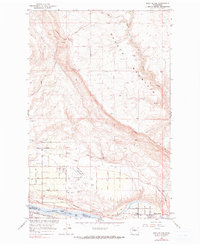
1966 Map of Rock Island
USGS Topo · Published 1990About this map
Badger Mountain dominates the northern reaches of this landscape, its steep slopes descending toward the intricate grid of the mid-century aviation and transit corridor. Below the heights, Pang Born Field sits as a central hub for the region, bordered by a dense network of residential and industrial streets such as Grant Road and 10th Street NE. The eastern bank of the Columbia River serves as the primary artery for industry and transport, where the Great Northern railroad parallels the water's edge near the settlement of Rock Island.
Find a feature on this map
43 named features on this map. Tap any name to fly to it.
Don’t see what you’re looking for? This feature index may not catch every label — zoom into the map to look around manually.
Map Details
Editions of this 1966 Rock Island Map
2 editions found
Other maps of this area

1901 · Chelan
USGS Topo · 1:125,000

1912 · Malaga
USGS Topo · 1:48,000

1913 · Wenatchee
USGS Topo · 1:62,500

1914 · Malaga
USGS Topo · 1:62,500

1915 · Wenatchee
USGS Topo · 1:62,500

1920 · Colockum Pass
USGS Topo · 1:125,000

1922 · Colockum Pass
USGS Topo · 1:125,000

1957 · Wenatchee
USGS Topo · 1:250,000
1966 · Malaga NE
USGS Topo · 1:24,000

1966 · Rock Island
USGS Topo · 1:24,000