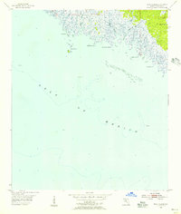
1955 Map of Rock Islands
USGS Topo · Published 1956About this map
Rock Islands and the tidal marshlands of the Florida Gulf Coast dominate this mid-century topographic study. The landscape is defined by the complex transition where the Fenholloway River and Henderson River meet the Gulf of Mexico. This coastal edge is dotted with named points and islands, including Rock Point, Stake Point, and Big Grassy Island, which sit amidst a network of Oyster Bars.
Find a feature on this map
13 named features on this map. Tap any name to fly to it.
Don’t see what you’re looking for? This feature index may not catch every label — zoom into the map to look around manually.
Map Details
Editions of this 1955 Rock Islands Map
Other maps of this area

1954 · Hampton Springs
USGS Topo · 1:24,000

1954 · Okefenokee Slough
USGS Topo · 1:24,000

1954 · Gainesville
USGS Topo · 1:250,000

1954 · Valdosta
USGS Topo · 1:250,000

1955 · Snipe Island
USGS Topo · 1:24,000

1955 · Rock Islands
USGS Topo · 1:24,000

1955 · Manlin Hammock
USGS Topo · 1:24,000
1956 · Hampton Springs
USGS Topo · 1:25,000

1958 · Valdosta
USGS Topo · 1:250,000

1958 · Gainesville
USGS Topo · 1:250,000