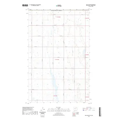
2020 Map of Rock Lake NW
USGS Topo · Published 2020About this map
The United States of America international border defines the northern edge of this North Dakota landscape, where the public land survey system organizes the terrain into a precise grid of sections and townships. Recorded in the year 2020, the topography is characterized by a high concentration of prairie potholes and small wetlands, which are interspersed throughout the agricultural fields. A network of rural corridors, including 67th Ave Ne and 72nd Ave Ne, provides access to the remote township sections of T164N R66W and T163N R66W. This survey illustrates the persistent geometry of Great Plains settlement, showing how modern infrastructure like 109th St Ne and 101st St Ne strictly adheres to the historic range lines established over a century ago. The absence of concentrated settlements highlights the area's enduring rural character and its focus on large-scale farming and natural drainage patterns.
Find a feature on this map
21 named features on this map. Tap any name to fly to it.
Don’t see what you’re looking for? This feature index may not catch every label — zoom into the map to look around manually.
Map Details
Editions of this 2020 Rock Lake NW Map
This is the sole edition of this map. No revisions or reprints were ever made.
Other maps of this area

1953 · Devils Lake
USGS Topo · 1:250,000

1956 · Devils Lake
USGS Topo · 1:250,000
1969 · Hansboro NE
USGS Topo · 1:24,000

1969 · Rock Lake NE
USGS Topo · 1:24,000
1969 · Rock Lake NW
USGS Topo · 1:24,000

1970 · Hansboro SE
USGS Topo · 1:24,000

1970 · Rock Lake
USGS Topo · 1:24,000

1970 · Rock Lake SE
USGS Topo · 1:24,000

1985 · Rock Lake
USGS Topo · 1:100,000
2011 · Rock Lake SE
USGS Topo · 1:24,000