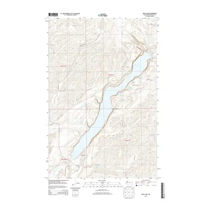
2014 Map of Rock Lake
USGS Topo · Published 2014About this map
Rock Lake dominates this portion of the Channeled Scablands, carved into the basalt of eastern Washington. The long, narrow body of water is fed by Negro Cr and Imbler Cr from the north, and surrounded by a complex system of smaller water features including Alkali Lake, Tule Lake, and Slaughter Pen Pond. Near the southern end of the lake, the settlement of Lavista sits along the Rock Lake Rd corridor, which follows the historic path of the railroad near Lavista Lake. On the eastern shore, Johnsons Beach serves as a notable landmark, while the prominent landmark Castle Rock rises above the water. The map traces a network of rural roads such as Miller Rd and Stephen Rd, which connect isolated homesteads and provide access through the complex drainage basins of Packer Cr and Kamiache Cr.
Find a feature on this map
38 named features on this map. Tap any name to fly to it.
Don’t see what you’re looking for? This feature index may not catch every label — zoom into the map to look around manually.
Map Details
Editions of this 2014 Rock Lake Map
This is the sole edition of this map. No revisions or reprints were ever made.
Other maps of this area

1954 · Cheney
USGS Topo · 1:62,500

1954 · Sprague
USGS Topo · 1:62,500

1955 · Spokane
USGS Topo · 1:250,000

1958 · Spokane
USGS Topo · 1:250,000

1964 · Lamont NE
USGS Topo · 1:24,000

1964 · St. John
USGS Topo · 1:24,000

1964 · Rock Lake
USGS Topo · 1:24,000

1964 · Texas Lake
USGS Topo · 1:24,000

1964 · Pine City
USGS Topo · 1:24,000

1964 · Ewan
USGS Topo · 1:24,000