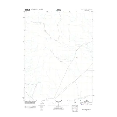
2012 Map of Rock Springs Pass
USGS Topo · Published 2012About this map
Rock Springs Pass serves as a central landmark in this high-elevation corner of White Pine County, where water is the primary driver of name and movement. The map details a network of vital water sources including Rock Springs, Blind Spring, and Dipping Tank Spring, which supported livestock and travelers through this arid Nevada terrain. The landscape is defined by its dramatic topography, featuring the distinctive formation known as The Mitten and the deep cuts of Red Rock Canyon. Transportation through the area is anchored by Whiskey Rd, which cuts diagonally across the southern half of the quadrangle toward the Antelope Valley Wash, illustrating the practical routes established for navigation through the Great Basin’s Basin and Range geography.
Find a feature on this map
11 named features on this map. Tap any name to fly to it.
Don’t see what you’re looking for? This feature index may not catch every label — zoom into the map to look around manually.
Map Details
Editions of this 2012 Rock Springs Pass Map
This is the sole edition of this map. No revisions or reprints were ever made.
Other maps of this area

1956 · Ely
USGS Topo · 1:250,000

1959 · Ely
USGS Topo · 1:250,000

1963 · Ely
USGS Topo · 1:250,000

1979 · Sunset Reservoir
USGS Topo · 1:24,000
1982 · Becky Peak
USGS Topo · 1:24,000
1982 · Silver Canyon
USGS Topo · 1:24,000
1982 · Stonehouse
USGS Topo · 1:24,000
1986 · Baldy Peak
USGS Topo · 1:24,000
1986 · Tippett Pass
USGS Topo · 1:24,000
1986 · Grass Valley Wash
USGS Topo · 1:24,000