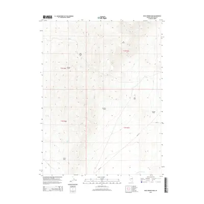
2014 Map of Rock Springs Pass
USGS Topo · Published 2014About this map
Antelope Range dominates this portion of White Pine County, forming a high divide between Spring Valley to the west and Antelope Valley to the east. The terrain is marked by a network of vital water sources, including Rock Springs and Dipping Tank Spring, which historically supported livestock and travelers in this arid high-desert environment. The namesake Rock Springs Pass serves as a critical topographic notch between these two broad basins. Evidence of the region’s ranching and transit history is preserved in the placement of labels like Whiskey Rd and Tippit Rd, which navigate the basin floors and skirt the base of peaks like The Mitten and Red Rocks. The drainage pattern of Antelope Valley Wash further illustrates the complex watershed management required in this part of Nevada.
Find a feature on this map
20 named features on this map. Tap any name to fly to it.
Don’t see what you’re looking for? This feature index may not catch every label — zoom into the map to look around manually.
Map Details
Editions of this 2014 Rock Springs Pass Map
This is the sole edition of this map. No revisions or reprints were ever made.
Other maps of this area

1956 · Ely
USGS Topo · 1:250,000

1959 · Ely
USGS Topo · 1:250,000

1963 · Ely
USGS Topo · 1:250,000

1979 · Sunset Reservoir
USGS Topo · 1:24,000
1982 · Becky Peak
USGS Topo · 1:24,000
1982 · Silver Canyon
USGS Topo · 1:24,000
1982 · Stonehouse
USGS Topo · 1:24,000
1986 · Baldy Peak
USGS Topo · 1:24,000
1986 · Tippett Pass
USGS Topo · 1:24,000
1986 · Grass Valley Wash
USGS Topo · 1:24,000