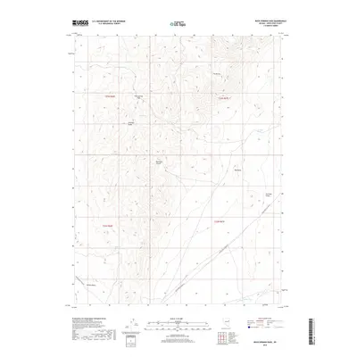
2018 Map of Rock Springs Pass
USGS Topo · Published 2018About this map
Rock Springs Pass serves as a critical high-altitude corridor through the Antelope Range, dividing the arid expanses of Spring Valley to the west from Antelope Valley to the east. This 2018 survey reveals a landscape where survival and movement are dictated by scarce water sources, including the strategically located Dipping Tank Spring and Rock Springs. These features indicate the persistent use of the land for livestock or wildlife, a pattern reinforced by the presence of White Pine Co Road 34 and White Pine Co Road 32 which navigate the base of the mountains. Striking topographical landmarks like The Mitten and the walls of Red Rock Canyon dominate the central terrain, while the Antelope Valley Wash provides a natural drainage route through the basin floor. The map offers a precise look at these remote high-desert features and their relationship to the historical ranching and travel routes of White Pine County.
Find a feature on this map
19 named features on this map. Tap any name to fly to it.
Don’t see what you’re looking for? This feature index may not catch every label — zoom into the map to look around manually.
Map Details
Editions of this 2018 Rock Springs Pass Map
This is the sole edition of this map. No revisions or reprints were ever made.
Other maps of this area

1956 · Ely
USGS Topo · 1:250,000

1959 · Ely
USGS Topo · 1:250,000

1963 · Ely
USGS Topo · 1:250,000

1979 · Sunset Reservoir
USGS Topo · 1:24,000
1982 · Becky Peak
USGS Topo · 1:24,000
1982 · Silver Canyon
USGS Topo · 1:24,000
1982 · Stonehouse
USGS Topo · 1:24,000
1986 · Baldy Peak
USGS Topo · 1:24,000
1986 · Tippett Pass
USGS Topo · 1:24,000
1986 · Grass Valley Wash
USGS Topo · 1:24,000