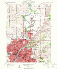
1949 Map of Rockford
USGS Topo · Published 1949About this map
The Rock River corridor anchors this post-war landscape, showing the rapid expansion of Rockford and Loves Park during a period of significant industrial and residential growth. The core of the city is densely detailed, featuring major institutional anchors such as Rockford College, the Court House, and a concentration of healthcare facilities including Swedish American Hosp, St Anthony Hosp, and the County Hosp.
Find a feature on this map
61 named features on this map. Tap any name to fly to it.
Don’t see what you’re looking for? This feature index may not catch every label — zoom into the map to look around manually.
Map Details
Editions of this 1949 Rockford Map
2 editions found
Other maps of this area

1917 · Kings
USGS Topo · 1:62,500

1918 · Rockford
USGS Topo · 1:62,500

1918 · Belvidere
USGS Topo · 1:62,500

1918 · Kings
USGS Topo · 1:62,500

1918 · Kirkland
USGS Topo · 1:62,500

1938 · Rockford
USGS Topo · 1:62,500

1944 · Belvidere
USGS Topo · 1:62,500

1949 · Camp Grant
USGS Topo · 1:24,000

1949 · Rockford
USGS Topo · 1:24,000

1954 · Rockford
USGS Topo · 1:250,000