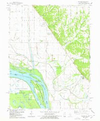
1978 Map of Rockport
USGS Topo · Published 1978About this map
The Mississippi River creates a complex system of islands and backwaters along the border of Illinois and Missouri in this late-1970s landscape. The Rockport settlement sits at the base of the eastern bluffs, where the river plain meets the higher elevations of Derry and Atlas townships. This map provides a detailed view of the extensive drainage engineering required to manage the bottomlands, including the Kiser Creek Diversion Ditch and Easley Ditch, alongside multiple settling basins designed to control siltation from the bluff-fed streams like Brown Branch.
Find a feature on this map
65 named features on this map. Tap any name to fly to it.
Don’t see what you’re looking for? This feature index may not catch every label — zoom into the map to look around manually.
Map Details
Editions of this 1978 Rockport Map
This is the sole edition of this map. No revisions or reprints were ever made.
Other maps of this area

1890 · Louisiana
USGS Topo · 1:125,000

1926 · Pittsfield
USGS Topo · 1:62,500

1930 · Nebo
USGS Topo · 1:62,500

1931 · Barry
USGS Topo · 1:62,500

1934 · Nebo
USGS Topo · 1:48,000

1936 · Barry
USGS Topo · 1:48,000

1937 · Bowling Green
USGS Topo · 1:62,500

1940 · Bowling Green
USGS Topo · 1:62,500

1942 · Nebo
USGS Topo · 1:62,500

1944 · Barry
USGS Topo · 1:62,500