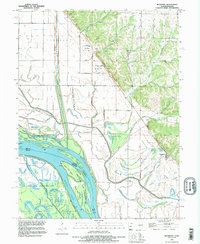
1991 Map of Rockport
USGS Topo · Published 1995About this map
The Mississippi River corridor dominates this 1991 survey, illustrating a landscape defined by sophisticated levee systems and water management infrastructure. Near the village of Rockport, the river’s complex side channels and islands, such as Murphy Island and Willow Bar Island, are mapped alongside the expansive Ted Shanks State Conservation Area. This area is characterized by a network of backwaters including Horseshoe Lake, Rainbow Pond, and Hickory Chute.
Find a feature on this map
59 named features on this map. Tap any name to fly to it.
Don’t see what you’re looking for? This feature index may not catch every label — zoom into the map to look around manually.
Map Details
Editions of this 1991 Rockport Map
This is the sole edition of this map. No revisions or reprints were ever made.
Other maps of this area

1890 · Louisiana
USGS Topo · 1:125,000

1926 · Pittsfield
USGS Topo · 1:62,500

1930 · Nebo
USGS Topo · 1:62,500

1931 · Barry
USGS Topo · 1:62,500

1934 · Nebo
USGS Topo · 1:48,000

1936 · Barry
USGS Topo · 1:48,000

1937 · Bowling Green
USGS Topo · 1:62,500

1940 · Bowling Green
USGS Topo · 1:62,500

1942 · Nebo
USGS Topo · 1:62,500

1944 · Barry
USGS Topo · 1:62,500