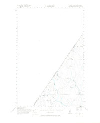
1955 Map of Rocky Brook
USGS Topo · Published 1966About this map
Black River flows through this remote section of northern Aroostook County, marking a landscape defined by its proximity to the international border. In the mid-1950s, this region remained dominated by forest and timber interests, evidenced by the network of Jeep Trails and the absence of established towns. The survey captures the transition between Quebec and Maine, tracing the jagged line where the Canada and United States border meets the North Woods. Smaller water bodies like Rideout Pond and Morrison Bk feed into the larger river systems that historically supported the logging industry. The map provides a look at the township divisions of the era, including T 19 R 12 and T 18 R 13, highlighting how land was partitioned for resource management in the deep interior of the state.
Find a feature on this map
14 named features on this map. Tap any name to fly to it.
Don’t see what you’re looking for? This feature index may not catch every label — zoom into the map to look around manually.
Map Details
Editions of this 1955 Rocky Brook Map
2 editions found
Other maps of this area

1930 · Allagash
USGS Topo · 1:48,000

1933 · Allagash
USGS Topo · 1:62,500

1955 · Rocky Mountain
USGS Topo · 1:62,500

1955 · Little East Lake
USGS Topo · 1:62,500

1955 · Rocky Brook
USGS Topo · 1:62,500

1955 · Beau Lake
USGS Topo · 1:62,500

1962 · Edmundston
USGS Topo · 1:250,000

1976 · East Lake
USGS Topo · 1:24,000
1987 · Johnson Brook Mountain
USGS Topo · 1:24,000

1987 · Hafey Pond
USGS Topo · 1:24,000