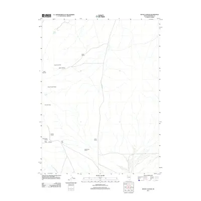
2011 Map of Rocky Canyon
USGS Topo · Published 2011About this map
The Seven Troughs Range dominates this Pershing County landscape, defined by a network of drainage systems including Rocky Canyon and Stonehouse Canyon. Human presence is concentrated near these lower elevations, where the Farrell Post Office and Marker House provide evidence of early 20th-century habitation and infrastructure. The ranching history of the Great Basin is preserved through labels such as the Circle L Cow Camp, positioned near the mouth of Stonehouse Canyon.
Find a feature on this map
15 named features on this map. Tap any name to fly to it.
Don’t see what you’re looking for? This feature index may not catch every label — zoom into the map to look around manually.
Map Details
Editions of this 2011 Rocky Canyon Map
This is the sole edition of this map. No revisions or reprints were ever made.
Other maps of this area

1931 · Lovelock
USGS Topo · 1:250,000

1935 · Lovelock
USGS Topo · 1:250,000

1955 · Lovelock
USGS Topo · 1:250,000

1959 · Lovelock
USGS Topo · 1:250,000

1981 · Dead Horse Canyon NE
USGS Topo · 1:24,000
1981 · Seven Troughs
USGS Topo · 1:24,000

1981 · Scossa
USGS Topo · 1:24,000

1981 · Placerites
USGS Topo · 1:24,000

1981 · Natchez Spring
USGS Topo · 1:24,000
1981 · Poker Brown Gap
USGS Topo · 1:24,000