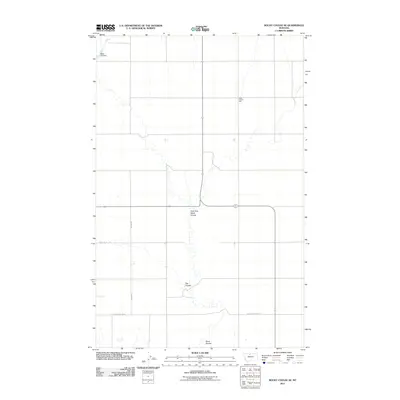
2011 Map of Rocky Coulee SE
USGS Topo · Published 2011About this map
Black Coulee Hall stands as a focal point for this rural Montana landscape, which is defined by the winding drainages that cut through the open plains of Hill County. The topography is shaped by the East Fork Black Coulee and Flat Coulee, waterways that direct the flow of the land toward Black Coulee in the south. These natural features are essential landmarks for navigating the vast northern ranges where water management is evident at the Black Cat Dam. The local transportation network consists primarily of section-line roads such as Boehm Rd and Black Coulee Rd W, which serve the scattered homesteads and agricultural operations. This survey documents the intersection of rural community life and the persistent natural drainage patterns of the northern Montana plains.
Find a feature on this map
8 named features on this map. Tap any name to fly to it.
Don’t see what you’re looking for? This feature index may not catch every label — zoom into the map to look around manually.
Map Details
Editions of this 2011 Rocky Coulee SE Map
This is the sole edition of this map. No revisions or reprints were ever made.
Other maps of this area

1906 · Lonesome
USGS Topo · 1:62,500

1919 · Big Sandy
USGS Topo · 1:125,000

1954 · Shelby
USGS Topo · 1:250,000

1958 · Shelby
USGS Topo · 1:250,000

1969 · Fourteenmile Coulee SW
USGS Topo · 1:24,000

1969 · Fourteenmile Coulee NW
USGS Topo · 1:24,000
1969 · Kenilworth
USGS Topo · 1:24,000

1969 · Dutch Henry Coulee
USGS Topo · 1:24,000
1969 · Discovery Butte
USGS Topo · 1:24,000
1970 · Rocky Coulee SE
USGS Topo · 1:24,000