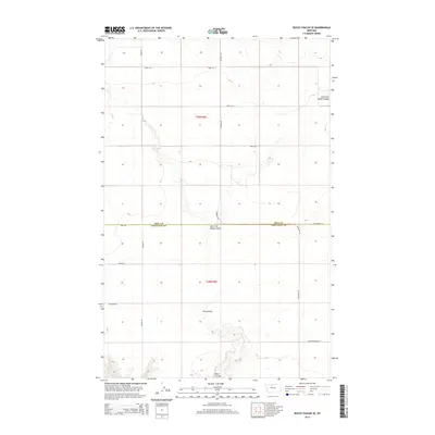
2014 Map of Rocky Coulee SE
USGS Topo · Published 2014About this map
The boundary between Hill County and Chouteau County divides this section of north-central Montana, defined by the winding drainages of the East Fork Black Coulee and Flat Coulee. The landscape is etched with the drainage patterns of the Black Coulee, which meanders through the southern half of the quadrangle. This 2014 survey illustrates the transition from a traditional grid-based section layout to the preservation of natural hydrological features.
Find a feature on this map
17 named features on this map. Tap any name to fly to it.
Don’t see what you’re looking for? This feature index may not catch every label — zoom into the map to look around manually.
Map Details
Editions of this 2014 Rocky Coulee SE Map
This is the sole edition of this map. No revisions or reprints were ever made.
Other maps of this area

1906 · Lonesome
USGS Topo · 1:62,500

1919 · Big Sandy
USGS Topo · 1:125,000

1954 · Shelby
USGS Topo · 1:250,000

1958 · Shelby
USGS Topo · 1:250,000

1969 · Fourteenmile Coulee SW
USGS Topo · 1:24,000

1969 · Fourteenmile Coulee NW
USGS Topo · 1:24,000
1969 · Kenilworth
USGS Topo · 1:24,000

1969 · Dutch Henry Coulee
USGS Topo · 1:24,000
1969 · Discovery Butte
USGS Topo · 1:24,000
1970 · Rocky Coulee SE
USGS Topo · 1:24,000