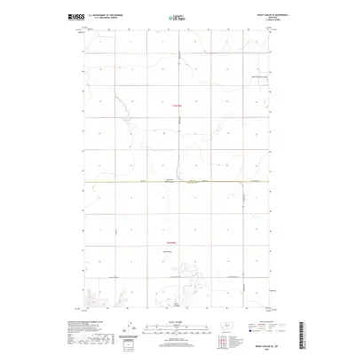
2020 Map of Rocky Coulee SE
USGS Topo · Published 2020About this map
Flat Coulee and the meandering drainage of Black Coulee define the heart of this North Central Montana landscape on the border of Hill and Chouteau counties. The map documents a strictly rural, high-plains geography where water dictates the land's utility, evidenced by the intricate contouring around East Fork Black Coulee. The rectilinear grid of the Public Land Survey System is clearly marked by gravel and dirt transit routes such as Rudyard Rd S and Tiber Rd, which serve the isolated farmsteads across Townships 29 and 30 North. This modern survey reflects the enduring cattle and wheat-growing legacy of the region, where roads like Black Coulee Rd W and Sand Dunes Rd follow the section lines of the open range.
Find a feature on this map
12 named features on this map. Tap any name to fly to it.
Don’t see what you’re looking for? This feature index may not catch every label — zoom into the map to look around manually.
Map Details
Editions of this 2020 Rocky Coulee SE Map
This is the sole edition of this map. No revisions or reprints were ever made.
Other maps of this area

1906 · Lonesome
USGS Topo · 1:62,500

1919 · Big Sandy
USGS Topo · 1:125,000

1954 · Shelby
USGS Topo · 1:250,000

1958 · Shelby
USGS Topo · 1:250,000

1969 · Fourteenmile Coulee SW
USGS Topo · 1:24,000

1969 · Fourteenmile Coulee NW
USGS Topo · 1:24,000
1969 · Kenilworth
USGS Topo · 1:24,000

1969 · Dutch Henry Coulee
USGS Topo · 1:24,000
1969 · Discovery Butte
USGS Topo · 1:24,000
1970 · Rocky Coulee SE
USGS Topo · 1:24,000