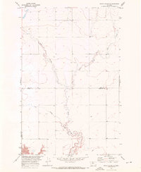
1970 Map of Rocky Coulee SE
USGS Topo · Published 1973About this map
Black Coulee dominates this rural expanse on the border of Hill and Chouteau counties. Surveyed as part of the Missouri River Basin development program, the landscape is defined by the winding course of the East Fork Black Coulee and Flat Coulee as they carve through the high plains. The map reveals the intricate drainage patterns of the era, reflecting the hydrologic focus of the U.S. Bureau of Reclamation and Geological Survey during the early 1970s. This specific sheet captures the transition from the upland flats to the steep, eroded breaks of the coulee systems, providing a detailed record of the natural topography before modern land-use changes.
Find a feature on this map
4 named features on this map. Tap any name to fly to it.
Don’t see what you’re looking for? This feature index may not catch every label — zoom into the map to look around manually.
Map Details
Editions of this 1970 Rocky Coulee SE Map
This is the sole edition of this map. No revisions or reprints were ever made.
Other maps of this area

1906 · Lonesome
USGS Topo · 1:62,500

1919 · Big Sandy
USGS Topo · 1:125,000

1954 · Shelby
USGS Topo · 1:250,000

1958 · Shelby
USGS Topo · 1:250,000

1969 · Fourteenmile Coulee SW
USGS Topo · 1:24,000

1969 · Fourteenmile Coulee NW
USGS Topo · 1:24,000
1969 · Kenilworth
USGS Topo · 1:24,000

1969 · Dutch Henry Coulee
USGS Topo · 1:24,000
1969 · Discovery Butte
USGS Topo · 1:24,000

1970 · Rocky Coulee SW
USGS Topo · 1:24,000