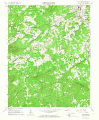
1965 Map of Rocky Mount
USGS Topo · Published 1967About this map
Rocky Mount serves as the focal point of this mid-1960s survey, situated where the Norfolk and Western railway winds through the complex valley of the Pigg River. The landscape is a network of small upland communities like Waidsboro and Barfoot, characterized by a high density of rural institutions such as Coles Creek Ch, Ebenezer Ch, and Waid Sch. Significant terrain features like Thornton Mountain and Cooks Knob define the topography, while early infrastructure such as the Radio Tower (WKWS) and a local Landing Strip signal the area's mid-century development. The numerous small cemeteries and family-named water bodies like Chestnut Creek provide a detailed view of the established settlement patterns in this part of Franklin County.
Find a feature on this map
51 named features on this map. Tap any name to fly to it.
Don’t see what you’re looking for? This feature index may not catch every label — zoom into the map to look around manually.
Map Details
Editions of this 1965 Rocky Mount Map
3 editions found
Other maps of this area

1890 · Roanoke
USGS Topo · 1:125,000

1890 · Christiansburg
USGS Topo · 1:125,000

1891 · Roanoke
USGS Topo · 1:125,000

1925 · Rocky Mount
USGS Topo · 1:48,000

1927 · Rocky Mount
USGS Topo · 1:62,500

1944 · Rocky Mount
USGS Topo · 1:62,500

1947 · Roanoke
USGS Topo · 1:250,000

1950 · Elliston
USGS Topo · 1:62,500

1951 · Boones Mill
USGS Topo · 1:62,500

1953 · Winston-Salem
USGS Topo · 1:250,000