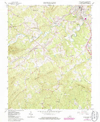
1965 Map of Rocky Mount
USGS Topo · Published 1986About this map
Rocky Mount serves as the focal point of this mid-1960s survey, where the winding Pigg River meets a network of local industry and infrastructure. The town's periphery includes the Filtration Plant and Sewage Disposal facilities, while the Norfolk and Western railway snakes through the landscape, connecting the county seat to outlying points like Waidsboro and Sixmile Post. The mapping reveals a community structured around its topography and faith, with numerous small congregations such as Antioch Ch, New Hope Ch, and Rock Ridge Ch dotting the hillsides.
Find a feature on this map
48 named features on this map. Tap any name to fly to it.
Don’t see what you’re looking for? This feature index may not catch every label — zoom into the map to look around manually.
Map Details
Editions of this 1965 Rocky Mount Map
3 editions found
Other maps of this area

1890 · Roanoke
USGS Topo · 1:125,000

1890 · Christiansburg
USGS Topo · 1:125,000

1891 · Roanoke
USGS Topo · 1:125,000

1925 · Rocky Mount
USGS Topo · 1:48,000

1927 · Rocky Mount
USGS Topo · 1:62,500

1944 · Rocky Mount
USGS Topo · 1:62,500

1947 · Roanoke
USGS Topo · 1:250,000

1950 · Elliston
USGS Topo · 1:62,500

1951 · Boones Mill
USGS Topo · 1:62,500

1953 · Winston-Salem
USGS Topo · 1:250,000