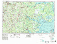
1954 Map of Rocky Mount
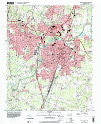
USGS Topo · Published 1954This historical map portrays the area of Rocky Mount in 1954, primarily covering Nash County as well as portions of Beaufort County, Chowan County, Dare County, Pamlico County, Washington County, Pitt County, Jones County, Wayne County, Craven County, Martin County, Wilson, Greene County, Carteret County, Hyde County, Bertie County, Lenoir County, Tyrrell County, Duplin County, and Edgecombe County. Featuring a scale of 1:250000, this map provides a highly detailed snapshot of the terrain, roads, buildings, counties, and historical landmarks in the Rocky Mount region at the time. Published in 1954, it is the sole known edition of this map.
Find a feature on this map
48 named features on this map. Tap any name to fly to it.
Don’t see what you’re looking for? This feature index may not catch every label — zoom into the map to look around manually.
Map Details
Editions of this 1954 Rocky Mount Map
This is the sole edition of this map. No revisions or reprints were ever made.
Historical Maps of Drexelbrook Through Time
8 maps found