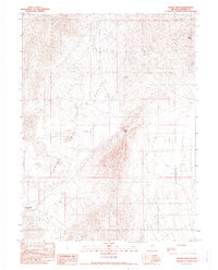
1990 Map of Rocky Pass
USGS Topo · Published 1990About this map
Rocky Pass serves as a narrow transit point between the expansive basins of Carico Lake Valley and Crescent Valley in this high-desert Nevada landscape. This late-twentieth-century survey documents a region defined by its arid geography and extractive industry, notably featuring the Carico Lake (Dry) bed to the southwest. Surface water is sparse, with intermittent flows like Elder Creek and Cooks Creek feeding the valley floors, while Dry Hill Spring provides a critical upland water source.
Find a feature on this map
17 named features on this map. Tap any name to fly to it.
Don’t see what you’re looking for? This feature index may not catch every label — zoom into the map to look around manually.
Map Details
Editions of this 1990 Rocky Pass Map
This is the sole edition of this map. No revisions or reprints were ever made.
Other maps of this area

1938 · Cortez
USGS Topo · 1:48,000

1944 · Cortez
USGS Topo · 1:62,500

1949 · Crescent Valley
USGS Topo · 1:62,500

1949 · Mt. Lewis
USGS Topo · 1:62,500

1950 · Mt. Lewis
USGS Topo · 1:62,500

1950 · Crescent Valley
USGS Topo · 1:62,500

1955 · Winnemucca
USGS Topo · 1:250,000

1958 · Winnemucca
USGS Topo · 1:250,000

1962 · Winnemucca
USGS Topo · 1:250,000

1962 · Carico Lake
USGS Topo · 1:62,500