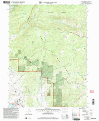
2000 Map of Rocky Peak
USGS Topo · Published 2004About this map
Rocky Peak dominates the central topography of this northern Colorado survey, situated within the protected lands of the Routt National Forest. To the north, the boundary of the Mount Zirkel Wilderness marks a transition into more primitive terrain, where the Cabin Creek Trail and Swamp Park Trail provide access to the high country. The landscape is deeply incised by drainages such as Mad Creek and Soda Creek, which flow toward the Yampa River in the southwestern corner. Near the river, the Steamboat Springs Airport and a nearby Gravel Pit indicate the footprint of local infrastructure and industry at the turn of the millennium. The network of water management, including the Hot Springs Ditch, highlights the importance of mountain runoff to the surrounding valleys, while recreation sites like Dry Lake and Elk Park anchor the public forest lands.
Find a feature on this map
29 named features on this map. Tap any name to fly to it.
Don’t see what you’re looking for? This feature index may not catch every label — zoom into the map to look around manually.
Map Details
Editions of this 2000 Rocky Peak Map
This is the sole edition of this map. No revisions or reprints were ever made.
Other maps of this area

1911 · Hahns Peak
USGS Topo · 1:125,000

1913 · Hahns Peak
USGS Topo · 1:125,000

1954 · Craig
USGS Topo · 1:250,000

1955 · Buffalo Pass
USGS Topo · 1:24,000

1955 · Mount Ethel
USGS Topo · 1:24,000

1955 · Mount Ethel
USGS Topo · 1:62,500

1956 · Storm Mountain
USGS Topo · 1:24,000

1956 · Rabbit Ears Peak
USGS Topo · 1:62,500

1957 · Craig
USGS Topo · 1:250,000

1958 · Craig
USGS Topo · 1:250,000