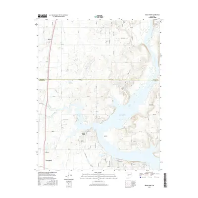
2016 Map of Rocky Point
USGS Topo · Published 2016About this map
Fort Gibson Lake dominates the eastern half of this landscape, its winding shoreline creating intricate geographical features such as Big Bend and the inlet at Flat Rock Bay. The terrain transitions from the water's edge into a network of rural routes and small settlements that define this portion of Mayes and Wagoner Counties. Cultural history is anchored by the Union Mission Cem near the northern boundary and the Fisher Cem further south, providing important points of interest for genealogists tracing local families. The map illustrates a quiet residential and agricultural area where names like Mazie, Murphy, and Yonkers persist as geographic markers. Significant local infrastructure is shown through the Fitzgerald-Soldier Cr Site 1 Reservoir and the rural road network, including Schaefer Ranch Rd, which connects the scattered homesteads and landings along the lake’s western reaches.
Find a feature on this map
84 named features on this map. Tap any name to fly to it.
Don’t see what you’re looking for? This feature index may not catch every label — zoom into the map to look around manually.
Map Details
Editions of this 2016 Rocky Point Map
This is the sole edition of this map. No revisions or reprints were ever made.
Other maps of this area

1896 · Pryor
USGS Topo · 1:125,000

1901 · Muscogee
USGS Topo · 1:125,000

1901 · Pryor
USGS Topo · 1:125,000

1905 · Muscogee
USGS Topo · 1:125,000

1946 · Fort Smith
USGS Topo · 1:250,000

1948 · Hulbert
USGS Topo · 1:62,500

1948 · Wagoner
USGS Topo · 1:62,500

1950 · Wagoner
USGS Topo · 1:62,500

1950 · Hulbert
USGS Topo · 1:62,500

1954 · Tulsa
USGS Topo · 1:250,000