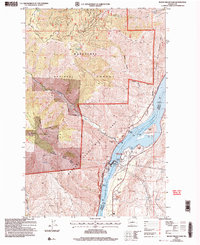
2003 Map of Rocky Reach Dam
USGS Topo · Published 2006About this map
Rocky Reach Dam dominates this section of the Columbia River, where hydroelectric infrastructure and resource management define the landscape. The river, widened into Lake Entiat behind the dam, serves as a hub for both industry and conservation, featuring a powerhouse, several substations, and a dedicated fish holding pond with a spawning run. This 2003 revision reveals the complex coordination between the Wenatchee National Forest and the State Wildlife Area, highlighting the intersection of industrial power generation and wildlife preservation.
Find a feature on this map
35 named features on this map. Tap any name to fly to it.
Don’t see what you’re looking for? This feature index may not catch every label — zoom into the map to look around manually.
Map Details
Editions of this 2003 Rocky Reach Dam Map
This is the sole edition of this map. No revisions or reprints were ever made.
Other maps of this area

1901 · Chelan
USGS Topo · 1:125,000

1912 · Malaga
USGS Topo · 1:48,000

1913 · Wenatchee
USGS Topo · 1:62,500

1914 · Malaga
USGS Topo · 1:62,500

1915 · Wenatchee
USGS Topo · 1:62,500

1920 · Colockum Pass
USGS Topo · 1:125,000

1922 · Colockum Pass
USGS Topo · 1:125,000

1957 · Wenatchee
USGS Topo · 1:250,000

1966 · Rock Island
USGS Topo · 1:24,000

1966 · Wenatchee
USGS Topo · 1:24,000