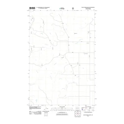
2011 Map of Rocky Ridge South
USGS Topo · Published 2011About this map
Ranching operations define the remote landscape of this southwestern North Dakota quadrangle during the early 21st century. The map illustrates a network of family-held lands, where the Petri Ranch and Peterson Ranch anchor the northern reaches near the headwaters of Philbrick Creek. These sites reflect the enduring agricultural traditions of Slope County, with established holdings like the Austin Ranch and Bock Ranch distributed along a sparse grid of rural roads. Water management is central to life here, evidenced by the Peterson Dam and the seasonal drainages of First Creek and Second Creek that carve through the open country. The cartography provides a clear view of the infrastructure supporting these isolated homesteads, including numerous secondary routes like 7695 and 769 that connect the high plains to the distant ranch houses.
Find a feature on this map
22 named features on this map. Tap any name to fly to it.
Don’t see what you’re looking for? This feature index may not catch every label — zoom into the map to look around manually.
Map Details
Editions of this 2011 Rocky Ridge South Map
This is the sole edition of this map. No revisions or reprints were ever made.
Other maps of this area

1953 · Dickinson
USGS Topo · 1:250,000

1957 · Dickinson
USGS Topo · 1:250,000

1961 · Daglum
USGS Topo · 1:62,500

1961 · Rocky Ridge
USGS Topo · 1:62,500

1973 · Black Butte
USGS Topo · 1:24,000

1973 · White Lake
USGS Topo · 1:24,000

1973 · Amidon
USGS Topo · 1:24,000

1980 · Belfield
USGS Topo · 1:100,000

1981 · Bowman
USGS Topo · 1:100,000
1982 · Daglum NW
USGS Topo · 1:24,000