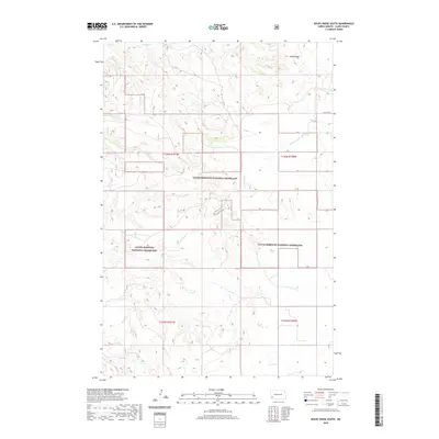
2020 Map of Rocky Ridge South
USGS Topo · Published 2020About this map
The Little Missouri National Grassland dominates this portion of Slope County, North Dakota, where the High Plains transition into a broken network of drainages and seasonal watercourses. The local hydrology is defined by a series of north-flowing tributaries including First Cr, Second Cr, and Third Cr, which carve through the undulating terrain. A significant landmark in the northern section of the map is Rocky Ridge, a topographic high point that overlooks the surrounding prairie. Evidence of the region's ranching and natural resource landscape appears in the presence of Big Spring, a vital water source in this semi-arid environment. The sectional layout is clearly defined by the Public Land Survey System grid, with 56th St SW providing one of the few formal transportation corridors through this expansive landscape of public and private grazing lands.
Find a feature on this map
12 named features on this map. Tap any name to fly to it.
Don’t see what you’re looking for? This feature index may not catch every label — zoom into the map to look around manually.
Map Details
Editions of this 2020 Rocky Ridge South Map
This is the sole edition of this map. No revisions or reprints were ever made.
Other maps of this area

1953 · Dickinson
USGS Topo · 1:250,000

1957 · Dickinson
USGS Topo · 1:250,000

1961 · Daglum
USGS Topo · 1:62,500

1961 · Rocky Ridge
USGS Topo · 1:62,500

1973 · Black Butte
USGS Topo · 1:24,000

1973 · White Lake
USGS Topo · 1:24,000

1973 · Amidon
USGS Topo · 1:24,000

1980 · Belfield
USGS Topo · 1:100,000

1981 · Bowman
USGS Topo · 1:100,000
1982 · Daglum NW
USGS Topo · 1:24,000