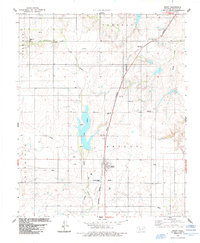
1984 Map of Rocky
USGS Topo · Published 1985About this map
Rocky serves as the central hub of this Oklahoma landscape, situated where the Burlington Northern railroad corridor meets a network of local roads in Washita County. The mid-1980s terrain is defined by the drainage of Little Elk Creek and Rocky Creek, which feed into the prominent Hobart Lake. Water infrastructure is a visible priority here, evidenced by a long aqueduct traversing the northeast and several water tanks positioned near the settlement.
Find a feature on this map
23 named features on this map. Tap any name to fly to it.
Don’t see what you’re looking for? This feature index may not catch every label — zoom into the map to look around manually.
Map Details
Editions of this 1984 Rocky Map
This is the sole edition of this map. No revisions or reprints were ever made.
Other maps of this area

1955 · Clinton
USGS Topo · 1:250,000

1956 · Cordell
USGS Topo · 1:62,500

1957 · Clinton
USGS Topo · 1:250,000

1957 · Dill City
USGS Topo · 1:62,500

1961 · Gotebo
USGS Topo · 1:62,500

1961 · Hobart
USGS Topo · 1:62,500

1976 · Dill City SE
USGS Topo · 1:24,000

1983 · Dill City
USGS Topo · 1:24,000
1983 · Dill City SE
USGS Topo · 1:24,000
1983 · Cordell
USGS Topo · 1:24,000