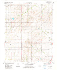
1983 Map of Dill City SE
USGS Topo · Published 1984About this map
Boggy Creek and its various branches, including West Boggy Creek and South Boggy Creek, drain the northern half of this Washita County landscape, while Cavalry Creek flows through the southern reaches. The 1980s cattle and agricultural character of the region is evident in the network of section-line roads and the scattered placement of Gas Wells and water tanks. The settlement at Braithwaite and the proximity to Cordell provide focal points for local history, with the Atchison Topeka and Santa Fe and Burlington Northern railroads serving as critical transport corridors for Oklahoma's plains. Genealogists will find significant value in the four named burial grounds shown, including Old Boggy Cem, Sod Cem, Dugford Cem, and Russell Cem, which provide clues to early family homesteads in the Bessie and Cordell districts.
Find a feature on this map
25 named features on this map. Tap any name to fly to it.
Don’t see what you’re looking for? This feature index may not catch every label — zoom into the map to look around manually.
Map Details
Editions of this 1983 Dill City SE Map
This is the sole edition of this map. No revisions or reprints were ever made.
Other maps of this area

1955 · Clinton
USGS Topo · 1:250,000

1956 · Cordell
USGS Topo · 1:62,500

1957 · Clinton
USGS Topo · 1:250,000

1957 · Dill City
USGS Topo · 1:62,500

1961 · Gotebo
USGS Topo · 1:62,500

1961 · Hobart
USGS Topo · 1:62,500

1976 · Dill City NE
USGS Topo · 1:24,000

1976 · Dill City SE
USGS Topo · 1:24,000
1983 · Bessie
USGS Topo · 1:24,000
1983 · Foss
USGS Topo · 1:24,000