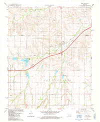
1983 Map of Foss
USGS Topo · Published 1984About this map
Foss sits at a strategic junction in western Oklahoma, where the Farmrail railroad and State Highway 66 meet the modern corridor of Interstate 40. This early 1980s landscape is defined by its water management and agricultural heritage, centered on the drainage of Turkey Creek and Clinton Lake. The terrain is marked by numerous family and community burial sites, including Old Foss Cem, Kerns Cem, and St Francis Cem, which offer significant value for genealogical research in Washita County. The map provides a detailed look at rural infrastructure, from the Waterworks and various Sew Disp Ponds to the network of local creeks like East Turkey Creek and West Turkey Creek. Fine red dashed lines throughout the quadrangle indicate selected fence and field lines, revealing the intricate land-use patterns of the era.
Find a feature on this map
24 named features on this map. Tap any name to fly to it.
Don’t see what you’re looking for? This feature index may not catch every label — zoom into the map to look around manually.
Map Details
Editions of this 1983 Foss Map
This is the sole edition of this map. No revisions or reprints were ever made.
Other maps of this area

1955 · Clinton
USGS Topo · 1:250,000

1957 · Clinton
USGS Topo · 1:250,000

1957 · Butler
USGS Topo · 1:62,500

1957 · Dill City
USGS Topo · 1:62,500

1960 · Hammon
USGS Topo · 1:62,500

1961 · Elk City
USGS Topo · 1:62,500

1976 · Butler SW
USGS Topo · 1:24,000

1976 · Dill City NE
USGS Topo · 1:24,000

1976 · Dill City SE
USGS Topo · 1:24,000
1976 · Butler SE
USGS Topo · 1:24,000