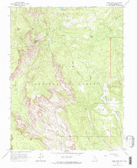
1964 Map of Roger Peak
USGS Topo · Published 1966About this map
Dixie National Forest dominates this high-altitude landscape in Garfield County, showcasing a complex network of plateaus and deep drainage systems mapped in the mid-1960s. The terrain is defined by the sharp drop-offs of Death Hollow and the Right Fork, while prominent elevations like Roger Peak and Mt Ogden anchor the horizon. A single grave is marked near the upper reaches of Salt Gulch, suggesting the solitary human presence often found in these remote grazing lands.
Find a feature on this map
26 named features on this map. Tap any name to fly to it.
Don’t see what you’re looking for? This feature index may not catch every label — zoom into the map to look around manually.
Map Details
Editions of this 1964 Roger Peak Map
2 editions found
Other maps of this area

1885 · Fish Lake
USGS Topo · 1:250,000

1886 · Escalante
USGS Topo · 1:250,000

1896 · Fish Lake
USGS Topo · 1:250,000

1952 · Notom 3 SW
USGS Topo · 1:24,000

1952 · Grover
USGS Topo · 1:62,500

1956 · Escalante
USGS Topo · 1:250,000

1956 · Salina
USGS Topo · 1:250,000

1960 · Escalante
USGS Topo · 1:250,000

1960 · Salina
USGS Topo · 1:250,000

1962 · Salina
USGS Topo · 1:250,000