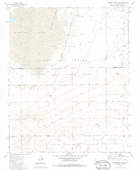
1973 Map of Rogers Lake South
USGS Topo · Published 1986About this map
Edwards Air Force Base dominates this desert landscape, where the vast dry expanse of Rogers Lake serves as a natural runway for aeronautical testing. The map details the infrastructure of the Air Force Flight Test Center in the early 1970s, including specialized sites like the Tracking Station and a Radio Facility. The southern portion of the sheet transitions into a desert plateau marked by Mt Mesa, where the terrain is crisscrossed by a grid of numbered streets such as 165th St and 210th Street, along with various Jeep Trails. Beyond the military operations, evidence of local industry remains through several labeled Mines, Prospects, and a Gravel Pit. The map also captures the political geography where the Kern Co Los Angeles Co line intersects the Military Reservation Boundary.
Find a feature on this map
27 named features on this map. Tap any name to fly to it.
Don’t see what you’re looking for? This feature index may not catch every label — zoom into the map to look around manually.
Map Details
Editions of this 1973 Rogers Lake South Map
2 editions found
Other maps of this area

1930 · Joshua
USGS Topo · 1:24,000

1931 · Hi Vista
USGS Topo · 1:24,000

1934 · Joshua
USGS Topo · 1:24,000

1935 · Hi Vista
USGS Topo · 1:24,000

1937 · Shadow Mountains
USGS Topo · 1:48,000

1937 · Kramer
USGS Topo · 1:48,000

1937 · Rogers Lake
USGS Topo · 1:48,000

1942 · Kramer
USGS Topo · 1:62,500

1942 · Shadow Mountains
USGS Topo · 1:62,500

1942 · Rogers Lake
USGS Topo · 1:62,500